Best Foot Forward: Blackstone Edge Moor


Beginning from the car park [Grid Ref SD 967 178] beneath the White House pub [postcode OL15 0LG] on the A58 between Littleborough and Ripponden, this is an excellent choice for those new to walking, or perhaps those with energetic and adventurous children who fancy a slightly longer stroll on a Sunday afternoon. It offers exceptional views of the dramatic moors on the Yorkshire/Lancashire border, allows you to feel as if in the middle of nowhere, whilst remaining only a stone’s-throw from civilisation. It is easy to navigate, but as always – take a map [OL21] and it is also relatively forgiving underfoot – despite the height of the landscape over which you will travel, the contours are gentle; you’re essentially exploring a natural plateau of the moorland, therefore there are very few inclines. So, whether you are new to walking, or perhaps trialling newly acquired boots, this would be a good place to start. That said, even for experienced walkers it is both a visually delightful walk, as well as a satisfying afternoon ramble.
Cross the main road and head south along the Pennine Way, clearly waymarked. On reaching a wooden gate, the Pennine Way turns left and climbs uphill, following what is believed to be a paved Roman road, although it has also been suggested that it was reconstructed in the mediaeval period, before becoming a Packhorse route from the 1700s. As you climb, behind you the district of Rochdale stretches to the horizon; to your left on the far hillsides there are the wind turbines that often cause a disagreement of opinion!
Advertisement
Hide AdAdvertisement
Hide AdYou will reach another obvious way marker and a wooden gate. To your left here sits the Aiggin Stone – its origins not clearly known. It’s thought to be about 600 years old; originally unearthed from moorland heather in the 1930s, it has subsequently provoked a number of opinions relating to its etymology and indeed, purpose. Thought to be an ancient way marker; it also has religious connotations, with travellers pausing to pray for safe passage over the moors. If you study it closely, you will see the letters I and T inscribed into the gritstone and whilst some suggest that Aiggin is a corruption of a Latin term “agger” [pile, heap, mound] others have suggested the name derives from the French “aguille” – a needle or sharp pointing rock.
Continue to follow the Pennine Way; as you reach the plateau you will weave your way through numerous boulders, upon which your adventurous children might like to scramble. Standing atop the stones; on a clear day you can see for miles, with moorland giving way to the urban sprawl. Shortly after the triangulation point, you should see Robin Hood’s Bed; a boulder with a hollowed-out crown, in which Robin Hood is said to have slept whilst his companions kept guard. Another curious piece of folklore talks of how no wind ever blows at this particular spot, despite the ferocious winds that frequently batter this edge.
The Pennine Way is helpfully paved for the next section, allowing for easy traverse. Follow it until you reach the motorway. It curves and will descend to meet the footbridge across the M62 and thus continues to Marsden and beyond. Here, do not cross the bridge, but follow the clear path as it curves round and meets the irrigation channel that will lead you to Green Withens Reservoir which was opened in 1898 and now home to the West Yorkshire Scouts’ Water sports Centre. On my recent walk, parts of this path were rather boggy, forcing us to skirt the edges of the track.
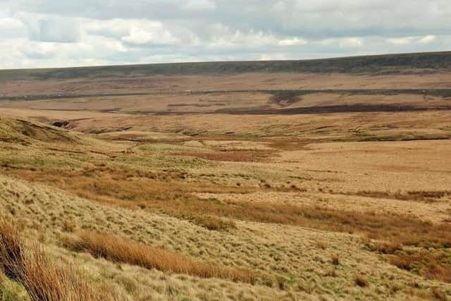
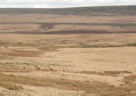
This is the point where I felt truly in the middle of nowhere. The noise of the motorway has faded and all around you are exposed to the vast, undulating landscape of the moors. The colours are innumerable; ochre competing with nutmeg-browns, dotted with olive green, whilst the ribbon of motorway gives way to the darker green of the far hills and the ever-changing dramatic skyline. On the day that we walked, all was calm, just a gentle breeze. The water reflected the sky like a mirror and the cries of the few ducks and geese were the only sign of animal companions in this remote, but beautiful landscape.
Advertisement
Hide AdAdvertisement
Hide AdFollow the edge or the reservoir until meeting another irrigation channel on the far side. Shortly up ahead there is a footbridge; go across this and take the gentle climb up Green Withens Edge. The path curves to the right and then back to the left; again, roughly following a watercourse. Parts of this path were rather soggy underfoot too, but it is a clearly defined route, passing the summit of Flint Hill to your right, and then with Great Manshead Hill coming into view in the distance as the land recedes to reveal another expanse of moorland beyond.
Once again you will cross the Old Packhorse Road – you cannot get lost as it is clearly way marked. Continue to follow the route until you meet the A58; turn left, walk along the edge of Blackstone Edge reservoir before returning to the car park. Gazing around one can really understand why this area is known to some as the “Roof of Yorkshire”.